Where is the smoke coming from?
Smoke on the Northern Bridger-Teton Forest
by Bridger-Teton National Forest
August 2, 2012
Neighbors to the Bridger-Teton National Forest especially in the Jackson Hole area have been looking for the source of the smoke that filled much of the valley on Thursday, August 2.
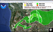
Weather and wind maps show that the smoke is likely from the northern part of the United States. http://www.osdpd.noaa.gov/ml/land/smoke.kml
Wildfire smoke is a mixture of small particles, gases, and water vapor. The very small particles, commonly referred to as "PM 2.5" or "fine particulate matter," are the most harmful to health. Smoke exposure can temporarily cause burning eyes, runny nose, scratchy throat, headaches, and illness. However, these symptoms usually disappear soon after one leaves the smoke. Smoke can seriously affect individuals whose health is already compromised, especially those with respiratory or cardiovascular disease. Older adults and children are also high-risk groups.
When a specific wildfire produces smoke with potential to impact human health nearby, the Forest Service, along with federal and state partners as appropriate, monitors smoke impacts to help inform the public if unhealthy conditions exist. The Wyoming Environment Department and the Wyoming Department of Environmental Quality are responsible for regulating pollutants under the Clean Air Act, including pollutants found in wildfire smoke. These state agencies ensure that air quality standards are met and maintained, issue permits, and enforce regulations.
For more information on wildfires and what individuals can do if they are affected by smoke visit www.tetonfires.com or the Wyoming Department of Environmental Quality: http://deq.state.wy.us/aqd/Smoke%20Management%20and%20Open%20Burning.asp.
The Forest Service data from smoke monitors near wildfires is available at http://www.satguard.com/usfs/default.asp. Click "Real Time Data" link.
Current fires on the Bridger-Teton include the Bear Cub Complex which is burning in the Teton Wilderness area near Moran, Wyoming. The fires in the complex include the 1-acre Butte Creek fire and the 6500-acre Bear Cub fire. The 64,083 acre Fontenelle fire is burning in the Wyoming Range near Big Piney, Wyoming. The Cache Creek Fire is less than Ľ of an acre burning on the ridge between Cache Creek and Game Creek just outside of Jackson, Wyoming and the Hams Fire is 1 Ľ acres and burning near Kemmerer, Wyoming.
The fire danger rating for the Bridger-Teton remains at "High" and partial fire restrictions are in place.
|