Pinedale Online!
www.PinedaleOnline.com
www.Pinedale.com

Pinedale on the Web!
Pinedale, Wyoming

Home | Calendar of Events | Photo Gallery | Local Businesses |

Pinedale Online > News > June 2012 > Fire Closure issued for Fontenelle Fire

Closure Map. Photo by Pinedale Online.
Closure Map
Closure Map as of Tuesday, June 26, 2012. (Map modified with labels by Pinedale Online)

Fire area proximity map. Photo by Pinedale Online.
Fire area proximity map
Map showing approximate location of the Fontenelle Fire.
Fire Closure issued for Fontenelle Fire
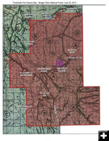
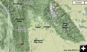
Fire has moved into Snyder Basin
by Pinedale Online!
June 26, 2012

The Bridger-Teton National Forest has issued an Emergency Area Closure for the Fontenelle Fire in the Wyoming Range for the protection of public health and safety.

The area closure includes parts of the Kemmerer and Big Piney Ranger Districts in Lincoln and Sublette County. The closure includes Snyder Basin, Thompson Pass, LaBarge Creek Road, LaBarge Meadows, Tri-Basin Divide, Wyoming Peak, Cheese Pass, Mount Isabel, Graham Peak, Red Park . The South and Middle Piney Creek roads are closed at the Forest boundary. All trails within the boundary area are closed due to the fire.

See this map for the Closure Notice and area map (PDF)


Pinedale Online > News > June 2012 > Fire Closure issued for Fontenelle Fire

Pinedale Online!
Pinedale Online! PO Box 2250, Pinedale, WY 82941
Phone: (307) 360-7689 or (307) 276-5699, Fax: (307) 276-5414

Office Outlet in Pinedale, 43 S. Sublette
E-mail:support@pinedaleonline.com

Copyright © 2012 Pinedale Online. All rights reserved.
Pictures and content cannot be used in whole or part without permission.