Major late spring snowstorm Sunday
Will impact travel over South Pass and central Wyoming
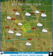
June 12, 2010
The National Weather Service advises that a major late spring snowstorm will continue to affect the east slopes of the Wind River Mountains, the Green and Rattlesnake Mountains and Casper Mountain Saturday night through noon Sunday.
A Winter Storm Warning remains in effect until noon Sunday for the eastern slopes of the Wind River Mountains.
A very strong late-season storm will move northeastward Saturday night and across southern Wyoming Sunday. Upslope flow will combine with unusually cold mid-June temperatures to produce a significant snowstorm. Lighter snow Saturday evening will become moderate to heavy again late Saturday night through Sunday morning. Snow levels will be around 7500 Saturday evening and then lower to between 6500 & 7000 feet late Saturday night and Sunday morning.
Heavy snow has accumulated down to around 7000 feet earlier Saturday and 10 to 15 inches has fallen above 7500 feet. There will be a break in the steady snow Saturday evening and then snow will redevelop after midnight and continue through around noon Sunday. Additional accumulations of 2 to 5 inches are expected above 7000 feet and an additional 4 to 7 inches are expected above 8000 feet. Total snow accumulations of between 18 and 30 inches are expected above 8000 feet with 10 to 15 inches above 7000 feet.
East to northeast winds of 15 to 25 mph with gusts to around 35 mph will continue over South Pass and exposed locations Saturday evening before diminishing to 10 to 20 mph Sunday morning. Visibilities will be reduced to one quarter mile or less due to snow and blowing snow over South Pass, mainly Saturday night after midnight. Travel over South Pass will become difficult again late tonight as moderate snow reduces visibility and causes slick roads.
A Winter Storm Warning for heavy snow means severe winter weather conditions are expected or occurring. Significant amounts of snow are forecast that will make travel dangerous. Only travel in an emergency. If you must travel, keep an extra flashlight, food and water in your vehicle in case of an emergency.
|