Horse Fire update – Monday, June 16, 2025
by Bridger-Teton National Forest
June 16, 2025
• Active: Exhibiting spotting and torching behavior.
• Size: 898 acres.
• Containment: 6 percent.
• Objectives: Full suppression.
• Resources Deployed: 3 engines, 1 Type 1 helicopter, 1 Type 3 helicopter, 2 Type 1 Hot Shot crews.
• Personnel: 82
*The updated acreage of the Horse Fire reflects the latest precise imaging of the fires perimeter.
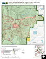
CLOSURE ORDER: A Horse Fire Area Road and Trail Closure is enacted from 7 a.m. on 6/16 through July 31 at 6 a.m. for public and firefighter health and safety during the Horse Fire, unless rescinded. Starting at Forest Road 10389 (Horse Creek Road), south along the Forest Boundary to Trial 2080 (Maki Creek) to Forest Road 10653 (Nylander Road), and northwest along Forest Road 10125 to Lincoln County Sublette County line to trail 2053 (North Horse Creek Trail) and east to Horse Creek Road. Forest Service Trial 2080 (Maki Creek Trail) and FS Roads 10653 and 10125 are open.
The described roads and trails include the following national forest system roads and trails located within and bordering the described area:
1. Forest Road 10341, 10346, 10389 (Horse Creek Road).
2. Portions of national forest system (NFS) trail numbers:
2053 (North Horse Creek), 2056 (Corlos Creek), 2047 (Old Indian),
3. NFS Trail Nos. 2082 (South Horse Creek), 2057 (Prospect Mountain)
Restrictions: Drones are prohibited to be flown anywhere near the fire area. Drones flying in the area of the fire on 6/14/25, halted aerial firefighting efforts for safety. When unauthorized drones enter wildfire airspace, firefighting aircraft are often grounded to prevent midair collisions. If you fly. We can’t. Drones are illegal in wildfire airspace.
|