
Middle Piney
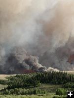
Fontenelle Fire running towards Middle Piney road, 6/28/12. Photo by Brandon Hampton.
|
|
Fontenelle Fact Sheet for Friday, June 29, 2012
by Bridger-Teton National Forest
June 29, 2012
Status: The Fontenelle Fire is burning on the Bridger-Teton National Forest approximately 17 miles west of Big Piney, Wyoming. The fire began on June 24, 2012. At this time the fire is 28,579 acres burning in heavy, dead timber and has burned into the Big Piney Ranger District.
Objectives for the Fire:
- Provide for firefighter and public safety
- Minimize impacts to oil/gas infrastructure & restore access as soon as safely possible
- Prepare and protect structures in Snider Basin
- Keep the fire to the east of Clear Creek
Recent Events: The increase in acreage over the past 24 hours is due to extreme fire behavior exhibited in the afternoon with running, torching and short duration crown fire in the Fish Creek drainage. Fire behavior is less extreme in the grass and sage found at lower elevations. The fire is currently burning to the northeast and has crossed the Fish Creek drainage. The fire began burning downhill toward Middle Piney creek late last night.
The incident management team will continue to develop and implement management actions as identified in the Forest Plan.
Today’s Strategy (Friday, June 29, 2012): Firefighters will continue to strengthen the anchor point on the southwest corner of the fire and begin constructing fireline on the left and right flanks. Structure protection is in place at the Middle Piney summer home area.
At 6:00 pm today, National Incident Management Organization (NIMO) Team will brief with the current incident management team as the incident transitions to a type 1 management team.
Forecast: A Red Flag warning remains in effect over the fire area until 9:00 pm this evening for winds and low relative humidity.
Closures: Road closures at present extend from the forest boundary at the top of Bare Pass at Red Castles, west to N. Piney Meadows and Tri Basin Divide, south to Cheese Pass, Mount Isabel, and Red Park, east to the junction of LaBarge Creek Road and the forest boundary, and north to Bare Pass. Further closures may be needed to ensure firefighter and public safety. The public is asked to be cautious when driving on the LaBarge Road between Hwy. 189 to the closure at the forest boundary as there may be large fire engines, fire traffic and impact from smoke.
More Information: Please visit www.fs.usda.gov/btnf, www.inciweb.org, or www.tetonfires.com, or follow us on Twitter at @WildeType2_IMT. Fire information phone 307-276-3324.
|