
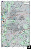
Oil Shale Map
Map showing the oil shale basin and tar sands areas in the states of Wyoming, Idaho, Utah and Colorado.
|
|
BLM identifies lands for potential development of significant oil shale resources
Includes public land around Daniel, Cora, Bondurant, Big Sandy
by Bureau of Land Management
September 5, 2008
The Bureau of Land Management today (Thursday, September 4 2008) finalized a plan to guide the use of public lands containing oil shale and tar sands. In its Final Programmatic Environmental Impact Statement (PEIS) published in today’s Federal Register , the BLM amends 12 land-use plans in Utah, Colorado, and Wyoming to set aside approximately 1.9 million acres of public lands for potential commercial oil shale development.
"The goal of the BLM’s oil shale program is to promote economically viable and environmentally sound production of oil shale on Western lands, where we estimate deposits hold the equivalent of 800 billion barrels of oil – enough to meet U.S. demand for imported oil at current levels for 110 years," said BLM Director Jim Caswell.
The Final PEIS is one in a number of steps required before commercial leasing would begin. This document summarizes information on oil shale and tar sands technologies and their potential environmental and socio-economic impacts, along with potential mitigating measures that would be evaluated and applied when subsequent site-specific National Environmental Policy Act (NEPA) analysis is undertaken for lease issuance or project approval.
Congress directed the BLM to develop the PEIS under Section 369(d) of the Energy Policy Act of 2005. The Act declares oil shale and other unconventional fuels to be strategically important domestic energy sources that should be developed to reduce the nation’s growing dependence on imported oil.
One of the next steps required would be completing rules that govern the procedures for issuing leases for development of oil shale and tar sands. However, Congress placed a moratorium in the fiscal year 2008 federal appropriations bill directing the BLM not to finalize such regulations.
"The President has urged Congress to lift its moratorium that prevents our agency from preparing final regulations that would move this program forward so that our nation can be more energy self-reliant," Caswell said.
Most U.S. oil shale resources are found in the Green River Formation of Colorado, Utah, and Wyoming. The PEIS identifies the most geologically promising oil shale areas in the three states that will be open to applications for commercial leasing.
The Draft PEIS was published in the Federal Register on December 21, 2007, for a 90-day public review and comment period. The BLM received more than 105,000 comments on the draft, resulting in the addition of clarifying text to the Final PEIS, but without significant changes to the land-use plan decisions proposed in the draft. The BLM will wait at least 60 days after the publication of the Final PEIS before signing and issuing a Record of Decision approving the land-use plan amendments.
Under the preferred management alternative in the Final PEIS, 305,000 acres of BLM-managed lands in the potential development area would be excluded from oil shale leasing. No leasing would be allowed in Wilderness Areas, Wilderness Study Areas, other units of the BLM’s National Landscape Conservation System, and Areas of Critical Environmental Concern closed to mineral development, along with other areas.
The Final PEIS is just one of several steps designed to harness these vast energy resources. The BLM has issued research, development, and demonstration (RD&D) leases for five oil shale projects in Colorado’s Piceance Basin and one in Utah. In July, the BLM also proposed regulations to set out the policies and procedures of a commercial program for oil shale resources on Federal lands. For additional information on the BLM’s efforts to develop Federal oil shale and tar sands resources, visit http://www.blm.gov/wo/st/en/prog/energy/oilshale_2.html.
For more information on this article contact: Matt Spangler, 202-452-5130.
_________________________________________
Editor’s Note: Click on this link (Oil Shale Map, 986K) for a map showing the oil shales and tar sands areas in the states of Wyoming, Idaho, Utah and Colorado. Areas shown as public lands containing oil shale basin being looked at for future development include land north, west and south of Pinedale; west and southwest of Daniel; between Daniel north to Bondurant; and in the Big Sandy area of the western front of the Wind River Range east of US 191 and southeast of Boulder and south to Farson and beyond, east into the Great Divide Basin.
|