Return to front page
Continuing News:
Wild Fires
Current information on wild fires near Pinedale, Wyoming, the western Wind River Mountains, the Wyoming Range, and the southern portion of the Bridger-Teton National Forest.
Fire Danger is Moderate
Partial Camp Fire Restrictions go in effect beginning Thursday, July 18
Fire Page sponsored by:
Triple Peak Lodge
Home | NIFC Current Wildfire Map | Bridger-Teton NF Fire Info | Teton Fires

Wild Fire Updates
Tuesday, July 16, 2002 -
10:00 pm

The Mule Creek Fire grew from 1600 acres yesterday to 4,000 today. Road and area closures in effect.
Bridger-Teton National Forest fire press releases

  • The Mule Creek Fire grew to an estimated 4,000 acres from yesterday to today moving east and north, dropping into Mill Creek and Dry Beaver drainages. The Horse Creek/Merna road has been closed at the Merna junction for public safety while fire fighters work on this fire. Only residents and people with business in the area will be allowed in. Area closures now in effect for North & South Beaver, Dry Beaver, Lead and Horse Creek drainages and associated access routes. The fire danger will be elevated to Very High as of Tuesday and partial fire restrictions will go into effect on Thursday. More Info | Fire Restrictions
  • Several fires are currently burning in Yellowstone National Park.
  • Fire restrictions are also in effect on BLM, State lands and Sublette County.
  • Mule Creek Fire Map

    Mule Creek Fire Map
    Click for larger map

    Local Fires at a Glance

    The Mule Creek Fire is burning in the Wyoming Range near Lookout Mtn on the Big Piney Ranger District. The Horse Creek road is currently closed to non-essential public travel at the forest boundary and area closures are in effect for the area north of Horse Creek.

    Geomac Fire Map web site

    Wyoming BLM Fire Page

    Mule Fire Perimiter Map (363K PDF)

    General Mule Fire Area Map (303K PDF)

    PDF images require Adobe Acrobat Reader to view. Note that you can zoom in on the PDF to get a closer view and image detail. Look for the zoom + button on your toolbar at the top of the page after the PDF loads in your browser.

    More Current Fire Information:
    The Mule Creek Fire grew to 4,000 acres today as winds pushed the fire over the northern ridge into Mill Creek and Dry Beaver Creek drainages overnight. Heavy spotting continued to occur east of the fire, fueled partly by thunderstorm cells that have brought very strong and erratic winds. So far, crews have been able to hold the southern edge of the fire on Horse Creek Road. The smoke from the fire drifted heavily into Pinedale during the late afternoon due to the wind shifts caused by the thunderstorm cell activity.
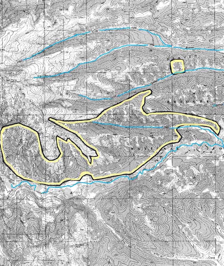
       The fire is located approximately 20 miles west of Daniel with its eastern edge six miles west of the Sherman Guard Station. It is one mile north of Prospect Peak and approximately one mile south of Horse Mountain on the Big Piney Ranger District. The fire is being called 10% contained and is moving into stands of more commercially desireable lodgepole. No structures are currently threatened by the fire. Rural homes are located several miles to the east and to the north of the fire, which has prompted the fire command team to start a structural protection analysis as a precautionary step in case the fire begins to threaten those areas. See the PDF links above for detailed maps showing the current fire perimeter and an area map showing a broader view of the fire in relation to Daniel, Hoback Ranches and Beaver Ridge.
        Due to steep terrain, hazardous conditions, and snags, crews are working in daylight hours only. There have been no serious injuries to date on the fire, with dehydration and altitude sickness being the most serious concerns that have been dealt with so far. Two new crews arrived today bringing the manpower on the ground to 240 people plus camp crews. Three helicopters, three air tankers, and two lead planes are still assigned to the fire. The Type II Team from North Carolina is now in charge of the fire, headed by Commander Dan Smith. Major developments today:

    • The fire pushed over the ridge into Mill Creek and Dry Beaver drainages with heavy spots to the east. Southern movement of the fire has been held at the Horse Creek Road. The fire movement has been east and north.
    • The Horse Creek Road is now closed past Merna Junction. Only local residents and people with business in the area will be allowed past the Sheriff's Office road block.
    • Area closures are now in effect for North Beaver, Dry Beaver, Lead Creek and Horse Creek and all associated access routes. The closure will be reviewed daily for applicability and will be lifted as soon as fire threats in the area are mitigated.
    • The IC team is initiating a structural protection analysis to identify potential threats to health and property. This analysisis a safety precautionary measure in case the fire continues to grow and threatens structures in the area.
    • The Incident Command Post was moved from Sherman Guard Station to a location on BLM land on the Cottonwood/Ryegrass road.

    Fire restrictions will go into effect beginning Thursday, July 18th on the Bridger-Teton National Forest and in Grand Teton National Park. The fire danger has been elevated to Very High as of Tuesday, July 16th. Daily Forest Service press release updates for this fire are available from the Bridger-Teton National Forest fire page. For more information, contact the Bridger-Teton National Forest at (307) 739-5500.

    Other area fires:
    The public is encouraged to report any new smoke columns they see. You can keep up with where the fires are burning by checking in on the National Interagency Fire Center (NIFC) Large Fire update page and Fire Map. Fires are also now burning in Yellowstone National Park. The Teton Fires web site also has interagency fire information links for the Bridger-Teton National Forest, Grand Teton National Park and Yellowstone National Park, www.tetonfires.com.

    CURRENT FIRE RESTRICTIONS

    Bridger-Teton National Forest:
    Partial fire restrictions go into effect on the Bridger-Teton National Forest beginning Thursday, July 18th. Back country users are reminded that campfires are not allowed above timberline in the wilderness at any time. Fireworks are prohibited at all times. Restrictions

    Sublette County
    Lighting fireworks is prohibited within Sublette County.

    BLM:
    Fire restrictions began July 4th. No open fires except within developed recreation sites. Regulations regarding smoking, operating a chain saw, and welder are in effect. No fireworks.

    State:
    Restrictions went into effect on State lands on June 11th.
    No open fires, barbecue grills or fireworks on any lands or facilities administered by the Game and Fish Department.

    Fire Page Sponsor

    Triple Peak Lodge
    Located on South Cottonwood Creek near the Wyoming Range
    triplepeak.com

    Please visit our sponsor's web site. They help make this fire update page possible!


    Links to earlier Fire Info:
    July 15, 2002
    July 14, 2002
    July 13, 2002
    July 6, 2002
    July 5, 2002
    July 4, 2002
    July 3, 2002
    July 2, 2002
    July 1, 2002
    June 30, 2002
    June 29, 2002
    2001 Fire Updates
    2000 Fire Updates

    For More Info on the Web

    Teton Fires
    Bridger-Teton National Forest

    National Interagency Fire Center NIFC
    NIFC Wildland Fire Map

    Where to get more information:
    Bridger-Teton NF Fire Info
    Mary Lendman or Jason Anderson
    307-739-5542 or 307-739-5564

    Pinedale Ranger District, BTNF
    307-367-4326

    Big Piney Ranger District, BTNF
    307-276-3375

    Where to report fires:
    Sublette County Sheriff's Office

    911 or 307-367-4378
    Pinedale Ranger District
    307-367-4326
    Big Piney Ranger District
    307-276-3375
    BTNF Supervisor's Office (Jackson)

    307-739-5500
    Teton Fire Dispatch
    (Grand Teton Park in Moose)

    307-739-3630
    307-739-3300

    Callers are reminded that if they are using a cell phone, they may not get a local office when they dial 911. The best place to call for area fires is either the local Sheriff's office or the Bridger-Teton Fire Office. Be prepared to give a location of the smoke, your name, where you are calling from, and how they can get ahold of you again for more information if needed.


    Anyone with concerns about fires can contact the Sublette County Sheriff's office at 307-367-4376, or the Pinedale Ranger District, 307-367-4326. Hikers in the wilderness who have cell phones (and can get a signal out) can call 911 and ask to be routed to the Sublette County Sheriff's office if they need to report a fire or have concerns. Be aware that 911 may route you to a different area other than Pinedale depending on where you are calling from.


    Return to Pinedale Online front page

    This Pinedale Online fire update is written by Dawn Svalberg from information obtained from the Pinedale Ranger District, the Jackson office of the US Forest Service Bridger-Teton National Forest, and online sources.  Copyright 2002.

    Pinedale Online!
    Located in Office Outlet, PO Box 662, Pinedale, WY 82941
    support@pinedaleonline.com
    307-367-6763

    www.pinedaleonline.com