Wild Fires
FIRE
DANGER IS:
Moderate
Moderate
| Continuing
News: Wild Fires |
FIRE
DANGER IS:
Moderate |
|
|
Latest
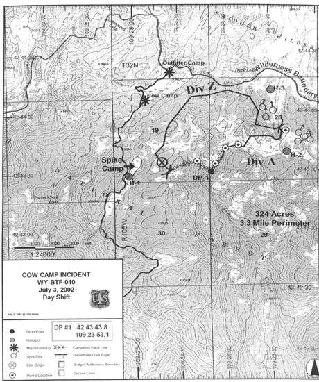
Wild Fire Updates Cow
Camp Fire Receives Additional Support The acreage on this fire has been increased to 366 acres due to more accurate GPS mapping data available. Containment is now at 50%. The fire is about 15 miles east of Boulder and 30 miles from Pinedale. Crews are working to protect an outfitter cabin and nearby cow camp. 185 people (seven crews) and one helicopter are presently working on the fire.
|
|
|
Current
Fire Information:
|
Fires at a Glance
National Wild Fire Incident Map
|
|
Links to earlier Fire Info: July
3, 2002
Where
to get more information: Pinedale
Ranger District, BTNF Big
Piney Ranger District, BTNF |
Where
to report fires: Callers are reminded that if they are using a cell phone, they may not get a local office when they dial 911. The best place to call for area fires is either the local Sheriff's office or the Bridger-Teton Fire Office. Be prepared to give a location of the smoke, your name, where you are calling from, and how they can get ahold of you again for more information if needed. |
| Anyone with concerns about fires can contact the Sublette County Sheriff's office at 307-367-4376, or the Pinedale Ranger District, 307-367-4326. Hikers in the wilderness who have cell phones (and can get a signal out) can call 911 and ask to be routed to the Sublette County Sheriff's office if they need to report a fire or have concerns. Be aware that 911 may route you to a different area other than Pinedale depending on where you are calling from. |
|
Return to Pinedale Online front page This Pinedale Online fire update is written by Dawn Svalberg from information obtained from the Pinedale Ranger District, the Jackson office of the US Forest Service Bridger-Teton National Forest, and online sources. Copyright 2002. |