| Friday,
August 18, 2000
Fire Location Graphics:
Earlier fire updates:
Revised
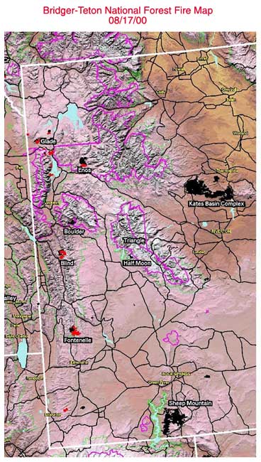
B-T fire map 8/17/00
More
Bridger-Teton fire Information available at:
|
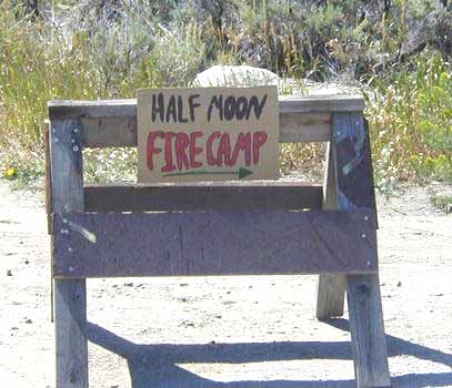
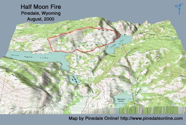
Half Moon fire basecamp is on Fremont Lake Pinedale Online photo 3-D fire maps!
|
Pinedale Online Fire Update - Friday, August 18, 8:00
pm
www.pinedaleonline.com, Pinedale,
Wyoming
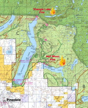
Half Moon & Triangle Lake Fire Updates
Information provided by the Pinedale Ranger District,
USFS
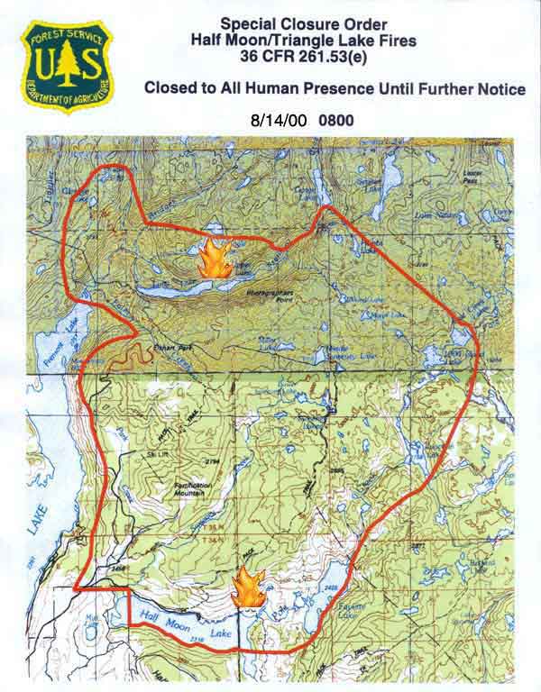
Revised Closure Map - 8/14/00 (0800)
Fire Danger Extreme! Forest-wide open fire ban in effect.
| Friday,
August 18, 2000
Fire Location Graphics:
Earlier fire updates:
Revised
B-T fire map 8/17/00
More
Bridger-Teton fire Information available at:
|
Half Moon fire basecamp is on Fremont Lake Pinedale Online photo 3-D fire maps!
|
|
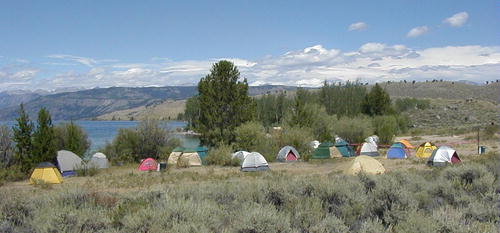
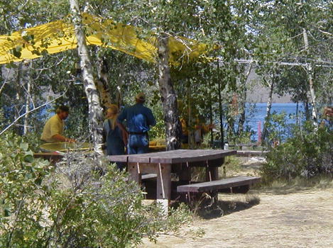
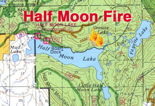
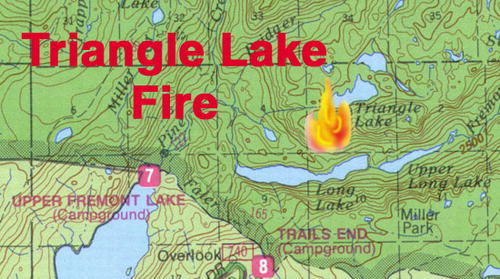
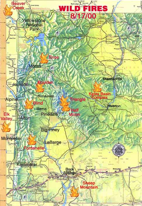
Pinedale Fire Update - Half Moon Lake & Triangle Lake fires Information provided by the Pinedale Ranger District, Bridger-Teton National Forest Fires at a Glance - Forest-wide open fire ban takes effect. Summary: The Half Moon & Triangle fires have been combined for management purposes and are under control of a Type II Overhead Team. Half Moon is expected to be 100% contained by tonight. The Triangle fire is burning within its perimeter within the Wilderness Area in very steep country. Today is the first day action has been taken on this fire with a helicopter being freed up to do bucket drops on the fire to keep it from creeping over into the timber on the west side. Four 20-man crews are on the ground working on the Half Moon fire, bringing the total force on the fire to approximately 123. Sandy Beach Picnic Area on the south end of Fremont Lake is being used as base camp. The Special Closure Order is still in effect for the Half Moon & Triangle Lakes fire areas. Only authorized firefighting personnel are allowed into the area. Visitors are being evacuated as they are encountered. A forest-wide ban on all open fires took effect today. Closure Map - Revised 8/14/00
at 8 am
Half Moon/Triangle Fires
Half Moon Fire Location: On northeast end of Half Moon Lake on
both sides of Pole Creek drainage, up to the west side of Fayette Lake,
up to the Sweeny Creek Pack Trail.
|
|
"We're not out of the woods yet." A forest-wide open fire ban took effect today which covers the entire Bridger-Teton National Forest and bans all open fires, including campfires in campgrounds. The exact wording for the restriction hasn't come down yet, but basically it will mean no open fires on the Forest. Liquid fuel only for stoves. FIRE DANGER IS EXTREMELY HIGH. Fires all around us are exploding, but the firefighters have thankfully got a pretty good handle on ours here. That doesn't mean, however, that they are under control. The Forest Service says that they hope to be able to call the fire 100% "contained" by tonight, meaning it is staying within a perimeter they are comfortable with and allowing it to consume fuels within those boundaries. This fire will continue to smoke and smolder probably until the snow
flies. Given the right conditions, there is still the possibility it could
rear up again if not taken care of now. The terrain is very rough and uneven,
with lots of pockets of Quaking Aspens and fir trees for the fire to move
through. "All it would take is a pretty good breeze for this fire to
spot again. These are the kind of fires that sneak back around and get
you." commented Cindy Stein of the Pinedale Other Area Fires
The Boulder fire, in the Gros Ventre Wilderness near Granite Hot Springs is approximately 30% contained. Gusty winds have created holding problems along the fire lines with active burning and torching being observed. Containment of the fire may allow reopening Granite Creek Road by early next week, but the area closure will remain in place indefinitely. Granite Hot Springs and the campground will be opening up, but the wilderness and trails to the wilderness will be closed. The Fontenelle fire west of LaBarge on Commissary Ridge is still making long range runs and spotting into active fires. This fire was at 18,000 acres today from 8,000 yesterday. So where can we go?
The big concern is over the extreme rate of spread of the fires happening all around us. The Forest Service wants to discourage people from coming now, even into other areas of the wilderness that don't have fires, because of the extremely high potential for new fires to start anywhere. The Bridger Wilderness is extremely rugged terrain (which is why people like it so much), which makes it potentially hard for hikers to escape and find exit points from these fires that are starting up and moving so quickly. The 1988 Fayette fire demonstrated that these wilderness fires keep going all the way to the Continental Divide. "We don't have high confidence hikers can find safety zones." said Stein. Some hikers think that they will be able to be rescued by helicopter if fires get close. The reality is that the all helicopters and resources are committed to all the fires in the area and the Bridger Wilderness gets 15,000 visitors in a season. Visitors are being discouraged from going into the wilderness areas at this time, and should be aware that the wilderness could potentially be shut down at any time, just as the Teton Wilderness has been. Even when these two fires are controlled, new ones can start up at any time. You're taking a BIG risk going into the wilderness at this time with the fire danger at extreme with the current conditions. Having said all that...the answer to the question of when can we get back into the wilderness is: Everything is day by day, but if things look good by tomorrow's reevaluation, it is possible that the Closure might be lifted by early next week opening up wilderness access via the Elkhart Park trailhead. MAYBE. As we write this update, a big lightning storm has rolled in and is thundering overhead. Three hel-attack firefighters have left to check out a couple of smokes...
To date, there have not been any fire related accidents for either the Half Moon or Triangle Lakes fires. Anyone with concerns can contact the Sublette County Sheriff's office at 307-367-4376, or the Pinedale Ranger District, 307-367-4326. Hikers in the wilderness who may have cell phones and can get a signal out can call 911 and ask to be routed to the Sublette County Sheriff's office if they have concerns. Because of all the fire activity going on, we have created a new site that has broader information about what is going on with fires on the Bridger-Teton National Forest. www.bridgertetonnationalforest.com We are working very closely with the Forest Service on the information on this site and updating it frequently. More area fire graphics:
|
|
Pinedale Online front page |